Quantifying the carbon consequences of land use decisions to inform climate planning and soil stewardship across Massachusetts.
Massachusetts soils store hundreds of millions of metric tons of carbon, yet until recently, the Commonwealth lacked a way to estimate how land-use decisions affect that carbon at a site-specific scale. The Soil Organic Carbon in Massachusetts (SOCMA) project addresses that gap.
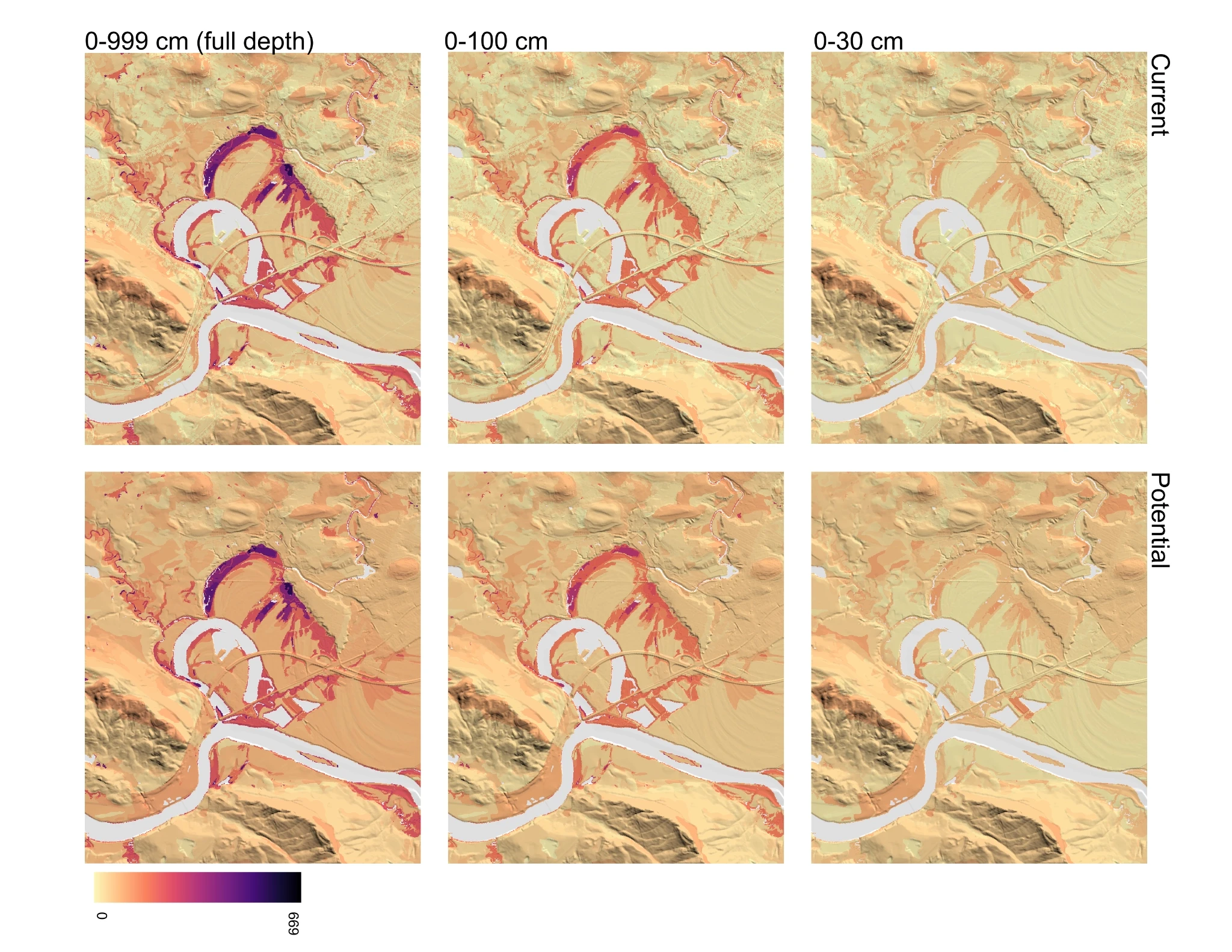
Developed through a Healthy Soils Challenge Grant from the Massachusetts Executive Office of Energy and Environmental Affairs (EEA), SOCMA produces high-resolution, land cover–adjusted GIS data layers estimating soil organic carbon (SOC) across the state. These layers allow planners, agencies, and land managers to evaluate how development, conservation, and restoration scenarios influence the carbon stored beneath our feet.
Unlike standard soil datasets, which typically assign a single carbon value to each soil mapping unit, SOCMA integrates SSURGO soil data with 1-meter land cover data. When soil carbon values were unavailable for a given soil–land cover combination, the team developed a method to identify the most similar soil type based on shared soil characteristics rather than simply using the nearest polygon. This approach produces a spatially explicit, land cover–adjusted carbon map suitable for climate modeling and planning.
More information and downloads are available on the MA Healthy Soils SOCMA page.
Client
Massachusetts Executive Office of Energy and Environmental Affairs (EEA)
Healthy Soils Challenge Grant
Partners
Services
- Analysis and modeling of soil organic carbon (SOC) stocks, segmented by soil type and land cover
- Integration of SSURGO soil data with 1-meter statewide land cover mapping
- Development of a soil similarity framework to estimate missing soil–land cover carbon values
- Production of GIS-ready layers for current and potential SOC conditions
- Development of land cover conversion factors to quantify carbon impacts of land use change
- Collaboration with NRCS soil scientists to refine methodology and interpretation
- Technical documentation and reporting
- Coordination with EEA and MassGIS for public data hosting and implementation